| Pages:
1
2 |
Fatboy
Senior Nomad

Posts: 805
Registered: 6-28-2005
Member Is Offline
|
|
El Camino Real (Again) Part 4 and the End
The whole time I am hiking in general I am always thinking about food after the first couple of days, I bring plenty but you do have to ration it to a
certain extent so it is always in the back of my mind and I always feel just a little hungry.
Then in the desert it is not just food, but also water. I just want to drink all I have and that last morning I only had about a cup left and didn't
feel like filter some since I was so close to the car.
Once at the car I drank a little, but just knowing I could have all I wanted seemed to quench my thirst, weird.
Car started (I have been known to leave something on and come back to a dead battery before) and I headed out.
Upon arriving at Rancho Nuevo, I made sure to wave at Francisco's wife who was out sweeping the porch and started leaving, when I heard yelling and
whistling coming from the rancho.
I stopped and got out, Francisco walked up to me and said he relieved him and his wife were to see me. They had prayed every night for me. I was truly
touched by his kindness.
He invited me in for coffee with him and his wife, which I very sadly declined.
Leaving there feeling overwhelmed by their kindness I wished I had taken him up on the offer.
Soon I was at La Sandia, the large sandy washed that worried me. I decided to try a different way out.
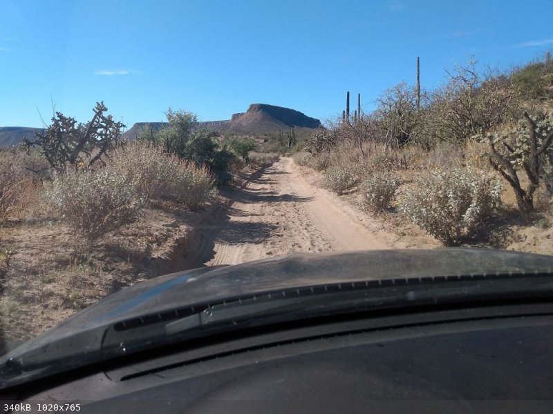
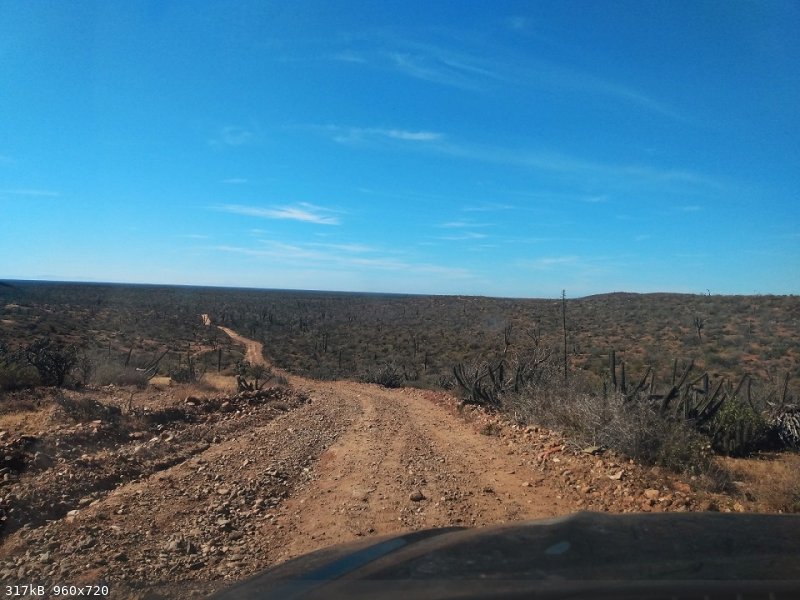
On and on I drove passing a few Rancho's in the 50 miles of dirt roads it took to reach pavement almost 3 hours later.
From there a quick stop in Villa Jesus Maria for a repeat of my visit of a week earlier. There was a young couple from Pennsylvania driving down the
peninsula for the first time and so we talked for a few minutes while I was waiting for my food.
I made it all the way to Laguna Salada where I spent my last night in Baja.
The next morning I followed Highway 5 to Highway 4 to Highway 3 to Highway 2 and I crossed at San Luis after my quickest border check in decades.
Read Part 1 here
Read Part 2 here
Read Part 3 here
[Edited on 1-17-2023 by Fatboy]
|
|
|
bajaric
Senior Nomad
Posts: 678
Registered: 2-2-2015
Member Is Offline
|
|
Great report, and promptly posted! I saw some horses near Calmalli, a little south of where you saw some horses. Wonder if they are wild or belong
to some rancho? Aschmann maintained that unlike burros, wild horses cannot survive in the central desert. I am not sure if that is true as there
appear to be wild horses in other desert areas.
|
|
|
Fatboy
Senior Nomad
Posts: 805
Registered: 6-28-2005
Member Is Offline
|
|
Horses seem to thrive in Nevada pretty well, but it does seem like burros do better in the 'drier' portions.
Based on where they were I would lean more towards wild, at least the ones I saw, but I am not sure.
|
|
|
Ateo
Elite Nomad
Posts: 5951
Registered: 7-18-2011
Member Is Offline
|
|
Killer report. Thank you for taking the time to post it. Funny how as soon as you get back to your car and have a bountiful supply of water, it tends
to calm the mind and thirst is quenched easily.
I love this area and will never forget my excursions in there for Baja 1000 trips.
Heading down that way in 2 weeks. Thanks for getting me excited for it!
|
|
|
David K
Honored Nomad
Posts: 65515
Registered: 8-30-2002
Location: San Diego County
Member Is Offline
Mood: Have Baja Fever
|
|
Thank you Fatboy for another chapter of you El Camino Real Quest.
Do you have a different area of it to examine/hike in mindfor the next time?
For Nomads (and lurkers) who would like to know where they might see El Camino Real, here are the places it joins or crosses modern roads, and a list
of links to maps of the Camino Real in Baja California: https://vivabaja.com/ecr-crossings/
|
|
|
Fatboy
Senior Nomad
Posts: 805
Registered: 6-28-2005
Member Is Offline
|
|
I really want to just does this section completely before thinking about anything else!
I did learn that I would not go up La Rabia, I would go straight to San Sebastian and then hike over the pass, that would have saved over a day of
travel.
|
|
|
David K
Honored Nomad
Posts: 65515
Registered: 8-30-2002
Location: San Diego County
Member Is Offline
Mood: Have Baja Fever
|
|
Super
The Jesuits also made detours and changes to earlier routes. There is no one El Camino Real. Any trail between missions, visitas, and water holes
(tinajas) you find may be one used by the missionaries and others before automobiles.
|
|
|
BornFisher
Super Nomad
Posts: 2133
Registered: 1-11-2005
Location: K-38 Santa Martha/Encinitas
Member Is Offline
|
|
All the elements of a great report, thanks for posting!
"When you catch a fish, you open the door of happiness."
|
|
|
advrider
Super Nomad
Posts: 1923
Registered: 10-2-2015
Member Is Offline
|
|
Thanks for posting. What was your total millage for the five days?
|
|
|
Fatboy
Senior Nomad
Posts: 805
Registered: 6-28-2005
Member Is Offline
|
|
Somewhere around 35.... Pretty low actually.... Day 5 was only a couple of hours of hiking.
|
|
|
advrider
Super Nomad
Posts: 1923
Registered: 10-2-2015
Member Is Offline
|
|
For the conditions and not knowing about water, that's not bad millage. If you over do it and run out of water, you could be in trouble fast.
|
|
|
4x4abc
Ultra Nomad
Posts: 4455
Registered: 4-24-2009
Location: La Paz, BCS
Member Is Offline
Mood: happy - always
|
|
Quote: Originally posted by Fatboy  | I really want to just does this section completely before thinking about anything else!
I did learn that I would not go up La Rabia, I would go straight to San Sebastian and then hike over the pass, that would have saved over a day of
travel. |
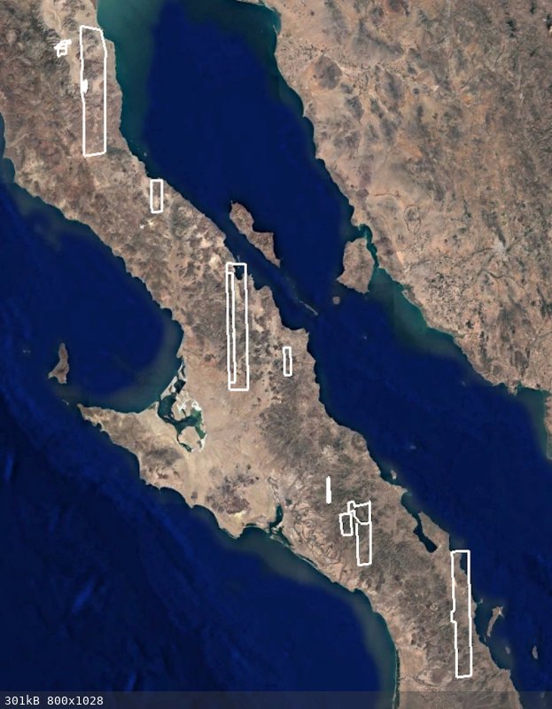
I revisited the area the last few days after your report.
I rediscovered a pass that I had completely forgotten.
It seems in excellent shape.
Maybe a strong alternative to the route a bit west of it
28°26'37.76"N, 113°34'11.70"W

Harald Pietschmann
|
|
|
4x4abc
Ultra Nomad
Posts: 4455
Registered: 4-24-2009
Location: La Paz, BCS
Member Is Offline
Mood: happy - always
|
|
| Quote: Originally posted by David K | Sharp eye, Harald.
Looks like a parallel trail that continues up the Arroyo San Sebastian canyon from Rancho San Sebastian site, then climbs out (your image), to head
west, to meet ECR about here: 28.443822, -113.569917 |
junction here:
28°26'52.29"N, 113°34'49.39"W
Harald Pietschmann
|
|
|
David K
Honored Nomad
Posts: 65515
Registered: 8-30-2002
Location: San Diego County
Member Is Offline
Mood: Have Baja Fever
|
|
| Quote: Originally posted by 4x4abc | | Quote: Originally posted by David K | Sharp eye, Harald.
Looks like a parallel trail that continues up the Arroyo San Sebastian canyon from Rancho San Sebastian site, then climbs out (your image), to head
west, to meet ECR about here: 28.443822, -113.569917 |
junction here:
28°26'52.29"N, 113°34'49.39"W |
Yes, the one above was your switchback waypoint (in decimal degrees) that was still in my mouse! My mouse failed to grab the one I wanted to past
here: 28.4489, -113.5805 or using Harald's format: 28°26'56.1" N, 113°34'49.8" W
This is just a few meters from your junction waypoint.
|
|
|
4x4abc
Ultra Nomad
Posts: 4455
Registered: 4-24-2009
Location: La Paz, BCS
Member Is Offline
Mood: happy - always
|
|
| Quote: Originally posted by David K | | Quote: Originally posted by 4x4abc | | Quote: Originally posted by David K | Sharp eye, Harald.
Looks like a parallel trail that continues up the Arroyo San Sebastian canyon from Rancho San Sebastian site, then climbs out (your image), to head
west, to meet ECR about here: 28.443822, -113.569917 |
junction here:
28°26'52.29"N, 113°34'49.39"W |
Yes, the one above was your switchback waypoint (in decimal degrees) that was still in my mouse! My mouse failed to grab the one I wanted to past
here: 28.4489, -113.5805 or using Harald's format: 28°26'56.1" N, 113°34'49.8" W
This is just a few meters from your junction waypoint. |

intyeresting is that Google is blocking out the view of that area
blocked areas have increased quite a bit over the last year
Harald Pietschmann
|
|
|
mtgoat666
Platinum Nomad
Posts: 20930
Registered: 9-16-2006
Location: San Diego
Member Is Online
Mood: Hot n spicy
|
|
| Quote: Originally posted by 4x4abc | | Quote: Originally posted by David K | | Quote: Originally posted by 4x4abc | | Quote: Originally posted by David K | Sharp eye, Harald.
Looks like a parallel trail that continues up the Arroyo San Sebastian canyon from Rancho San Sebastian site, then climbs out (your image), to head
west, to meet ECR about here: 28.443822, -113.569917 |
junction here:
28°26'52.29"N, 113°34'49.39"W |
Yes, the one above was your switchback waypoint (in decimal degrees) that was still in my mouse! My mouse failed to grab the one I wanted to past
here: 28.4489, -113.5805 or using Harald's format: 28°26'56.1" N, 113°34'49.8" W
This is just a few meters from your junction waypoint. |
intyeresting is that Google is blocking out the view of that area
blocked areas have increased quite a bit over the last year |
How does Google control the weather?
Woke!
Hands off!
“Por el bien de todos, primero los pobres.”
“...ask not what your country can do for you – ask what you can do for your country.” “My fellow citizens of the world: ask not what America
will do for you, but what together we can do for the freedom of man.”
Pronoun: the royal we
|
|
|
bajaric
Senior Nomad
Posts: 678
Registered: 2-2-2015
Member Is Offline
|
|
Chemtrails. 
It almost looks like there are two parallel trails that split apart before San Sebastion and then rejoin farther north. Maybe, as DK said, the
Jesuits made an alternate trail to replace the first one. That switchback trail that Harald found screams "Jesutis".
Or, someone else made a new trail. There was a little mining around there, Gabb saw an arrastra at San Sebastion in 1867. Miners were great road
builders. They did not have Indian labor, but they made up for it with explosives. Or a trail made by ranchers.
Thanks again for sharing that trip report. A place that very few people have seen in person. The return trip to Jesus Maria looks like a decent
graded road and an alternate to going the long way past El Arco. Any way points or Rancho names that you passed en route?
[Edited on 1-20-2023 by bajaric]
|
|
|
4x4abc
Ultra Nomad
Posts: 4455
Registered: 4-24-2009
Location: La Paz, BCS
Member Is Offline
Mood: happy - always
|
|
Google can select sat images with clouds or without clouds
they can also select images with bad resolution or good resolution
here is what is currently fuzzy or cloud covered:
Harald Pietschmann
|
|
|
mtgoat666
Platinum Nomad
Posts: 20930
Registered: 9-16-2006
Location: San Diego
Member Is Online
Mood: Hot n spicy
|
|
| Quote: Originally posted by 4x4abc |
Google can select sat images with clouds or without clouds
they can also select images with bad resolution or good resolution
here is what is currently fuzzy or cloud covered:
|
actually, google attempts to procure images with least cloud cover. but sometimes that is all that is available from the image vendors. some parts
of the world are just not photographed often, because there are little or no buyers for images of remote areas.
sat photo vendors focus on imaging what sells. there is no benefit from photographing remote baja areas if no one wants to buy or use the images.
do you think google wants to pay extra for images of remote areas if very few people are looking at remote areas?
Woke!
Hands off!
“Por el bien de todos, primero los pobres.”
“...ask not what your country can do for you – ask what you can do for your country.” “My fellow citizens of the world: ask not what America
will do for you, but what together we can do for the freedom of man.”
Pronoun: the royal we
|
|
|
Fatboy
Senior Nomad
Posts: 805
Registered: 6-28-2005
Member Is Offline
|
|
I did go out the Jesus Maria way and the first half from Rancho Nuevo until out of the mountains doesn't seem to be used very much. It was a little
tougher in some spots and at times it looked like I was on a road that did not go anywhere and that had me a little concerned.
I passed 3 ranchos on the way out 1 looked deserted and the other 2 looked lived in and working ranchos. I didn't time it or check the mileage so I am
not sure which was shorter and/or quicker but coming from the north I would go back this way.
I do believe that Ranchos Los Corralles/Nuevo/Santa Cruz use a different way to get in and out, it is probably the quickest/easiest way and I wonder
where it is?
| Quote: Originally posted by bajaric | Chemtrails.
It almost looks like there are two parallel trails that split apart before San Sebastion and then rejoin farther north. Maybe, as DK said, the
Jesuits made an alternate trail to replace the first one. That switchback trail that Harald found screams "Jesutis".
Or, someone else made a new trail. There was a little mining around there, Gabb saw an arrastra at San Sebastion in 1867. Miners were great road
builders. They did not have Indian labor, but they made up for it with explosives. Or a trail made by ranchers.
Thanks again for sharing that trip report. A place that very few people have seen in person. The return trip to Jesus Maria looks like a decent
graded road and an alternate to going the long way past El Arco. Any way points or Rancho names that you passed en route?
[Edited on 1-20-2023 by bajaric] |
|
|
|
| Pages:
1
2 |


