| Pages:
1
2
3 |
David K
Honored Nomad

Posts: 64491
Registered: 8-30-2002
Location: San Diego County
Member Is Offline
Mood: Have Baja Fever
|
|
Quote: Originally posted by 4x4abc  | here is a Google Earth overlay with the geo map
download the Leon Grande Overlay kmz
and download the map image below
open kmz in GE
"ctrl - I" ("cmd - I" on Mac) the overlay kmz
then link to the downloaded jpg
|
The overlay is not matched in scale to the GE map...
|
|
|
David K
Honored Nomad
Posts: 64491
Registered: 8-30-2002
Location: San Diego County
Member Is Offline
Mood: Have Baja Fever
|
|
That was fun... several trails or roads, or parts of roads, between Parador Punta Prieta and the place we had earlier agreed was Leon Grande (at least
as shown on maps): Here: 29.0284, -114.2547
Perhaps these hills are rich with gold and there are naturally many prospects or placer deposits that were checked out. That one straight piece of
road, with with a detour around the excavated ramp (or natural but straight gully), was interesting. Here: 29.0648, -114.1814
Thanks Harald!
|
|
|
David K
Honored Nomad
Posts: 64491
Registered: 8-30-2002
Location: San Diego County
Member Is Offline
Mood: Have Baja Fever
|
|
Who knows for sure where this La Venada is, or they just used an old name from some 1920s map?
|
|
|
4x4abc
Ultra Nomad
Posts: 4167
Registered: 4-24-2009
Location: La Paz, BCS
Member Is Offline
Mood: happy - always
|
|
Mina La Venada official location according to register: 29° 1.693'N, 114° 15.288'W
La Venada is what we thought for some time to be Leon Grande
well, it is on the trail to Leon Grande - but it was not Leon Grande
[Edited on 4-13-2023 by 4x4abc]
Harald Pietschmann
|
|
|
4x4abc
Ultra Nomad
Posts: 4167
Registered: 4-24-2009
Location: La Paz, BCS
Member Is Offline
Mood: happy - always
|
|
| Quote: Originally posted by David K | | Quote: Originally posted by 4x4abc | here is a Google Earth overlay with the geo map
download the Leon Grande Overlay kmz
and download the map image below
open kmz in GE
"ctrl - I" ("cmd - I" on Mac) the overlay kmz
then link to the downloaded jpg
|
The overlay is not matched in scale to the GE map...
|
you use the controls of the overlay box to scale the map using the reference points (grab and drag the corners until the image fits)
you'll figure it out
pretty easy
Harald Pietschmann
|
|
|
4x4abc
Ultra Nomad
Posts: 4167
Registered: 4-24-2009
Location: La Paz, BCS
Member Is Offline
Mood: happy - always
|
|
| Quote: Originally posted by David K |
Spelled on all modern maps as La Bachata, along the highway at Km. 24.5 is an abandoned home with a triangle window: 28.8365, -114.1252 (this is a few
hundred feet west of your point, across the highway).
|
I used La Vachata because that is the name on the map
and on this old map La Vachata sits a bit east in the Arroyo Palo Chino and not on the highway
Harald Pietschmann
|
|
|
David K
Honored Nomad
Posts: 64491
Registered: 8-30-2002
Location: San Diego County
Member Is Offline
Mood: Have Baja Fever
|
|
| Quote: Originally posted by 4x4abc | Mina La Venada official location according to register: 29° 1.693'N, 114° 15.288'W
La Venada is what we thought for some time to be Leon Grande
well, it is on the trail to Leon Grande - but it was not Leon Grande
[Edited on 4-13-2023 by 4x4abc] |
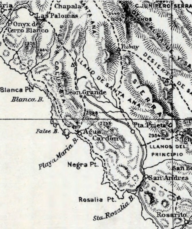
Which is the Leon Grande location of all maps (seems to me) from the 1920s to 1971... With the '71 Geology map being highly detailed and accurate. The
wagon/auto road ending north from Punta Prieta there, is also a solid clue.
1919 map of wagon roads and trails:
|
|
|
4x4abc
Ultra Nomad
Posts: 4167
Registered: 4-24-2009
Location: La Paz, BCS
Member Is Offline
Mood: happy - always
|
|
v and b are often exchanged in Baja
https://www.google.com/search?q=letter+v+and+b+in+mexico&...
Harald Pietschmann
|
|
|
David K
Honored Nomad
Posts: 64491
Registered: 8-30-2002
Location: San Diego County
Member Is Offline
Mood: Have Baja Fever
|
|
| Quote: Originally posted by 4x4abc | Mina La Venada official location according to register: 29° 1.693'N, 114° 15.288'W
La Venada is what we thought for some time to be Leon Grande
well, it is on the trail to Leon Grande - but it was not Leon Grande
[Edited on 4-13-2023 by 4x4abc] |
The road ends there and the distance to Punta Prieta matches, so if that isn't Leon Grande, please show it to us and the wagon road that ends at Leon
Grande, from 100 years ago. I am rereading the Hale book pages, which I have posted here on Nomad in the past.
Let me know if anyone would like to see them again, about this area of Agua Leon, Leon Grande, and Punta Prieta.
|
|
|
4x4abc
Ultra Nomad
Posts: 4167
Registered: 4-24-2009
Location: La Paz, BCS
Member Is Offline
Mood: happy - always
|
|
the road between Mina La Venada and Mina Leon Grande is partially well defined - see attached track
the last section between Aguaja Leon Grande (2 springs) and Mina Leon Grande is no longer detectable
understandable since it follows an Arroyo and there is no local ranch activity
seems like the Mina La Venada people have maintained the road to the spring - but not beyond that
interesting is the crop planting activity at the lower spring 29° 2.566'N, 114° 16.322'W
early 2000 images are best in detail

Attachment: 4x4 rural mining trail Manantial Leon Grande.kmz (3kB)
This file has been downloaded 59 times
Harald Pietschmann
|
|
|
4x4abc
Ultra Nomad
Posts: 4167
Registered: 4-24-2009
Location: La Paz, BCS
Member Is Offline
Mood: happy - always
|
|
I see a number of indicators for a trail network between the 2 defined roads

Harald Pietschmann
|
|
|
David K
Honored Nomad
Posts: 64491
Registered: 8-30-2002
Location: San Diego County
Member Is Offline
Mood: Have Baja Fever
|
|
Good morning, Harald.
I am trying very hard to see any sign of mine activity at your location for Leon Grande, 3 miles beyond 'my' location. Can you show us what you see
that makes you think it was a busy mine on a close up sat image?
Thank you!
|
|
|
4x4abc
Ultra Nomad
Posts: 4167
Registered: 4-24-2009
Location: La Paz, BCS
Member Is Offline
Mood: happy - always
|
|
| Quote: Originally posted by David K | Good morning, Harald.
I am trying very hard to see any sign of mine activity at your location for Leon Grande, 3 miles beyond 'my' location. Can you show us what you see
that makes you think it was a busy mine on a close up sat image?
Thank you! |
not sure - but that is where the road ends
no good sat images of that area
Harald Pietschmann
|
|
|
bajaric
Senior Nomad
Posts: 605
Registered: 2-2-2015
Member Is Offline
|
|
| Quote: Originally posted by David K | | Quote: Originally posted by 4x4abc | Mina La Venada official location according to register: 29° 1.693'N, 114° 15.288'W
La Venada is what we thought for some time to be Leon Grande
well, it is on the trail to Leon Grande - but it was not Leon Grande
[Edited on 4-13-2023 by 4x4abc] |
"Which is the Leon Grande location of all maps (seems to me) from the 1920s to 1971... With the '71 Geology map being highly detailed and accurate."
end quote
DK, as I have politely pointed out several times "your" Leon Grande ((La Venada) is 3 miles south of the location for Leon Grande that is shown on
the 1971 Geological map. The 1921 map shows Leon Grande 8 miles due south of Agua Leon, which is also north of La Venada. La Venada is not the Leon
Grande location of all maps. It is the location on no maps.
Leon Grande was a water hole on the old north south trail. Water was so scarce in this area that finding water was literally a matter of life and
death for travelers on foot. That is why it is shown on all the maps from the 1920's when the trail was in use. It is interesting that no one on
here, myself included, know exactly where the water hole or spring was located. Harald has put forth some reasonable possibilities, though I think
the trail was well east of La Venada, running along the eastern flanks of the Sierra Columbia between Mesa el Leoncito and Punta Prieta. There are so
many old mining trails in there it is hard to say which one is the north-south trail.
La Venada appears to be a modern mine. That is why the road to it is so visible on Google Earth. The north-south trail was a burro trail that was
only in use for a short time before it was abandoned, so it is probably pretty faint. Even in 1921 it was faint, as Hale and his companion noted when
they lost the trail and almost died before the heard the sound of singing, and found a road crew camped at Leon Grande, a pool of water below a source
in a cliff.
|
|
|
|
David K
Honored Nomad
Posts: 64491
Registered: 8-30-2002
Location: San Diego County
Member Is Offline
Mood: Have Baja Fever
|
|
| Quote: | | Quote: Originally posted by bajaric | | Quote: Originally posted by David K | | Quote: Originally posted by 4x4abc | Mina La Venada official location according to register: 29° 1.693'N, 114° 15.288'W
La Venada is what we thought for some time to be Leon Grande
well, it is on the trail to Leon Grande - but it was not Leon Grande
[Edited on 4-13-2023 by 4x4abc] |
"Which is the Leon Grande location of all maps (seems to me) from the 1920s to 1971... With the '71 Geology map being highly detailed and accurate."
|
DK, as I have politely pointed out several times "your" Leon Grande ((La Venada) is 3 miles south of the location for Leon Grande that is shown on
the 1971 Geological map. The 1921 map shows Leon Grande 8 miles due south of Agua Leon, which is also north of La Venada. La Venada is not the Leon
Grande location of all maps. It is the location on no maps.
Leon Grande was a water hole on the old north south trail. Water was so scarce in this area that finding water was literally a matter of life and
death for travelers on foot. That is why it is shown on all the maps from the 1920's when the trail was in use. It is interesting that no one on
here, myself included, know exactly where the water hole or spring was located. Harald has put forth some reasonable possibilities, though I think
the trail was well east of La Venada, running along the eastern flanks of the Sierra Columbia between Mesa el Leoncito and Punta Prieta. There are so
many old mining trails in there it is hard to say which one is the north-south trail.
La Venada appears to be a modern mine. That is why the road to it is so visible on Google Earth. The north-south trail was a burro trail that was
only in use for a short time before it was abandoned, so it is probably pretty faint. Even in 1921 it was faint, as Hale and his companion noted when
they lost the trail and almost died before the heard the sound of singing, and found a road crew camped at Leon Grande, a pool of water below a source
in a cliff.
|
Well, I think we all need to go explore the area. Also, a careful reading of Hale's words is in order. Do we have any other book references to Leon
Grande? Thanks to 'geoffff' we have photos and gps for Agua Leon. 'My' Leon Grande came from the 1971 map, which shows it as a mine. I measured the
spot from nearby known locations (Yubay, Punta Prieta, old L.A. Bay jcn. with old main road, etc.). I will do it again, and see where the 1971 map
spot goes on Google Earth, this time! Ha! First, I will dig up the original location discovery post... stand by! LOL |
|
|
|
mtgoat666
Select Nomad
Posts: 17339
Registered: 9-16-2006
Location: San Diego
Member Is Offline
Mood: Hot n spicy
|
|
Wrong. Here is the claim site mapped as Leon grande claim on 1971 map. On GE you can see disturbed ground of previous workings, and it is exactly
where 1971 map has it mapped.
29°04'51"N 114°14'49"W
There may have been a local spring or rancho named Leon grande; to find such, you should stop at local ranchos and inquire.
And this is Mina Columbia shown on 1971 geo map. 28°56'01"N 114°14'40"W
Leon grande was a prospect. Columbia was a bit more than a prospect, but may have never reached appreciable production
[Edited on 4-15-2023 by mtgoat666]
Woke!
“...ask not what your country can do for you – ask what you can do for your country.” “My fellow citizens of the world: ask not what America
will do for you, but what together we can do for the freedom of man.”
Prefered gender pronoun: the royal we
|
|
|
4x4abc
Ultra Nomad
Posts: 4167
Registered: 4-24-2009
Location: La Paz, BCS
Member Is Offline
Mood: happy - always
|
|
| Quote: Originally posted by David K |
Well, I think we all need to go explore the area. Also, a careful reading of Hale's words is in order. Do we have any other book references to Leon
Grande? Thanks to 'geoffff' we have photos and gps for Agua Leon. 'My' Leon Grande came from the 1971 map, which shows it as a mine. I measured the
spot from nearby known locations (Yubay, Punta Prieta, old L.A. Bay jcn. with old main road, etc.). I will do it again, and see where the 1971 map
spot goes on Google Earth, this time! Ha! First, I will dig up the original location discovery post... stand by! LOL |
I did an overlay with the 1971 map
it puts Leon Grande at 29° 3.773'N, 114° 15.830'W
1.4 miles away from the location we think is Leon Grande
2.6 miles away from La Venada

[
[Edited on 4-15-2023 by 4x4abc]
Harald Pietschmann
|
|
|
David K
Honored Nomad
Posts: 64491
Registered: 8-30-2002
Location: San Diego County
Member Is Offline
Mood: Have Baja Fever
|
|
It is something to get the goat interested in cartography and history!
"Where o'where is Leon Grande, where o'where could it be..."
Previous threads with Leon Grande chat & maps:
http://forums.bajanomad.com/viewthread.php?tid=96760
http://forums.bajanomad.com/viewthread.php?tid=96243
http://forums.bajanomad.com/viewthread.php?tid=95950
http://forums.bajanomad.com/viewthread.php?tid=78559
http://forums.bajanomad.com/viewthread.php?tid=78635
http://forums.bajanomad.com/viewthread.php?tid=35262
On Jan. 23, 2012 is the first mention of this area from a Nomad search (last link above). I commented about Agua Leon (confusing it with Leon Grande):
"Agua Leon would be an interesting ghost town to find... north of Punta Prieta, and west into the hills. It is written about in the book 'Long
Walk to Mulege'."
|
|
|
| Pages:
1
2
3 |


